
GeoRank
GeoRank is a relocation research tool that compares places on sunshine, cost, tax, and visa data, then lets you ask AI about your shortlist.
VisitPublished on:
July 14, 2026
Pricing:
About GeoRank
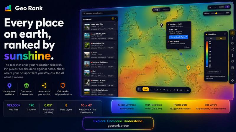
GeoRank is a free, no-signup interactive map tool designed to replace the scattered research process of deciding where to relocate or spend an extended stay abroad. Instead of juggling a dozen open tabs across weather sites, cost-of-living databases, embassy pages, and nomad forums that never talk to each other, GeoRank layers eight comprehensive data sets over a global grid with approximately five-kilometer resolution. The platform covers sunshine and temperature calibrated against 182 ground stations using SARAH-3 satellite data, ERA5 reanalysis, and CHELSA climate models. It also integrates tax rates from OECD, PwC, and KPMG sources, per-passport visa and residency routes across 47 destinations for 10 different passports, cost-of-living data from 478 cities, geopolitical risk assessments, and a community-sourced Nomad Pulse sentiment indicator. Users can pin candidate locations, switch to Compare mode to see every metric as a delta against their current home, and ask an AI assistant that reasons only over their own shortlist with cited, grounded answers. GeoRank is built for the actual decision of where to live next, not just for browsing data. It serves digital nomads, remote workers, retirees, expatriates, and anyone evaluating relocation options by providing a single, coherent decision tool that eliminates guesswork and conflicting information sources.
Features of GeoRank
Explore Globally with Nine Live Layers
Toggle nine live data layers on the interactive map, including sunshine, temperature, rainfall, outdoor hours, taxes, visas and residency options, cost of living, geopolitical risk, and Nomad Pulse sentiment. Pan across the entire globe and zoom down to approximately five-kilometer cells to inspect conditions at any location. Each layer is a live data source you can turn on or off independently, and clicking any layer reveals its underlying methodology, data sources, accuracy ratings, and update frequency. This approach lets you stack multiple layers simultaneously to understand how different factors combine at any given point on earth, from urban centers to remote countryside locations.
Pin and Compare Against Your Home Base
Click any location on the map to pin it to your personal shortlist, with support for up to 20 pinned places that save across sessions. Switch to Compare mode and set your current home location as a baseline. Every pinned place then displays a delta against your home, showing how much warmer, cheaper, safer, or differently taxed each candidate location is compared to where you live now. This relative comparison transforms raw numbers into meaningful context, answering questions like "how many more sunshine hours does this place offer than my current city?" or "how much cheaper is rent here compared to home?"
Chat Your Shortlist with Grounded AI
Once you have pinned your locations, the AI chat feature provides answers that a simple table cannot deliver. The AI operates exclusively on your pinned locations and their associated data, not on a generic knowledge base. Ask questions like "which of my five places has the best winter?" or "score my shortlist by sunshine, cost, and low tax combined" and receive cited, grounded answers that reason across all your candidate locations in a single response. Every answer includes source references, such as GeoRank sunshine data from SARAH-3 and ERA5, OECD Tax Database entries, or PwC Worldwide Tax Summaries, ensuring transparency and trust in the recommendations.
Nomad Pulse Community Sentiment Layer
The Nomad Pulse layer tracks weekly sentiment from the digital nomad community by processing social posts into rising, stable, or falling signals per country and city. This community-sourced data reveals where enthusiasm is building before it becomes mainstream knowledge, giving you an edge in identifying emerging destinations. Unlike official statistics that lag behind real-world conditions, Nomad Pulse captures the lived experience of people already on the ground, providing a dynamic, current perspective on how desirable a location feels to the nomadic community at any given time.
Use Cases of GeoRank
Evaluating Winter Bases for Remote Work
A remote worker holding a UK passport wants to escape the dark, cold winter months and is considering five candidate locations across Southern Europe and Southeast Asia. Using GeoRank, they pin each location, set their current home as the baseline, and ask the AI "which of my pinned places is best for a winter base?" The AI evaluates sunshine hours, temperature, cost of living, and visa duration for their specific passport, then delivers a ranked comparison with cited data. The user discovers that while one location offers the most sunshine, another provides a better combination of warmth, affordability, and visa-free access, enabling an informed decision that balances multiple priorities.
Comparing Tax Implications for Freelancers
A freelance consultant based in the United States is exploring relocation to reduce their tax burden while maintaining a high quality of life. They pin Tbilisi, Paphos, Lisbon, Medellin, and Kuala Lumpur, then set their home as the baseline. In Compare mode, they see the delta for income tax rates, cost of living, and sunshine hours. They ask the AI "I want low tax and at least 2,800 sunshine hours, which works better?" The AI identifies that Paphos meets the sunshine threshold with a non-dom tax regime, while Tbilisi falls short on sunshine but offers significantly lower living costs and zero tax on foreign-sourced income. The consultant can then weigh these tradeoffs with precise numbers rather than vague impressions.
Family Relocation Decision Support
A family with young children is considering relocating from London to either Paphos or Tbilisi and needs to understand the tradeoffs beyond simple metrics. They pin both locations, set London as their baseline, and ask the AI "what are the tradeoffs between Paphos and Tbilisi for a family?" The AI analyzes sunshine hours, outdoor hours suitable for children, geopolitical risk ratings, cost of living for a family of four, visa duration for their passport, and tax implications. It produces a structured comparison that highlights how Paphos offers more outdoor time and lower geopolitical risk but higher costs, while Tbilisi provides a lower cost of living and longer visa-free stays but less sunshine and higher risk. The family can then investigate specific schools and housing with a clear understanding of the foundational differences.
Retirement Destination Planning
A retiree with a Canadian passport wants to maximize sunshine and minimize cost of living while ensuring geopolitical stability and accessible healthcare. They pin multiple candidate locations across Central America, Southern Europe, and Southeast Asia. Using the Compare mode with their current home as baseline, they see that several locations offer more than 1,000 additional sunshine hours per year while cutting living costs by half or more. The AI helps them narrow down by asking "which of my pinned places has the best combination of sunshine, low cost, and low geopolitical risk?" The answer ranks locations by their composite score, with cited data for each metric, allowing the retiree to focus their deeper research on the top two or three candidates.
Frequently Asked Questions
How is the sunshine data calibrated and how accurate is it?
Sunshine data comes from SARAH-3 satellite observations merged with ERA5 reanalysis data, then bias-corrected against 182 ground stations with orographic terrain corrections. These stations span diverse climates from Reykjavik to Phoenix to Sydney, ensuring global applicability. Accuracy is approximately plus or minus eight percent for most locations, with high-altitude areas reaching plus or minus fifteen percent and coastal microclimates at plus or minus twenty percent. The data is updated monthly as a climatology, meaning it reflects long-term averages rather than real-time conditions. This calibration approach corrects for the tendency of raw satellite data to overestimate sunshine in cloudy regions, providing a more reliable baseline for decision-making.
Do I need to create an account or pay to use GeoRank?
No, GeoRank is completely free and requires no signup or account creation. You can access the interactive map, toggle all nine data layers, pin up to twenty locations, switch to Compare mode, and use the AI chat feature without providing any personal information or payment. Pinned locations save across sessions using browser storage, so your shortlist persists when you return. There are no subscription tiers, premium features, or usage limits. The tool is designed to be immediately accessible for anyone evaluating relocation options, removing barriers to entry that might slow down the research process.
How does the AI chat feature work and what data does it use?
The AI chat operates exclusively on your pinned locations and their associated data from GeoRank, not on a general knowledge base or internet search. When you ask a question like "which of my five places has the best winter?" the AI retrieves the specific metrics for each pinned location, including sunshine hours, temperature ranges, cost of living figures, tax rates, visa durations, and geopolitical risk scores. It then reasons across all these data points to produce a comparative answer with cited sources. Every response includes references to the underlying data layers, such as SARAH-3 sunshine data, OECD tax tables, or PwC tax summaries, allowing you to verify the information. The AI cannot answer questions about locations you have not pinned or about topics outside the available data layers.
What is Nomad Pulse and how is it different from other sentiment data?
Nomad Pulse is a community-sourced sentiment indicator that tracks weekly signals from the digital nomad community by processing social media posts into rising, stable, or falling trends per country and city. Unlike official statistics from government agencies or international organizations that may be months or years old, Nomad Pulse captures current, lived experiences of people already on the ground. This provides early insight into where enthusiasm is building before it becomes widely known, helping you identify emerging destinations that may not yet appear in traditional rankings. The signal is categorized as rising, stable, or falling, giving you a directional sense of community sentiment rather than a precise numerical score.
Similar to GeoRank


Privacy-first, cookieless web analytics that ties your traffic and marketing channels to real Stripe revenue.

Signage and kiosk infrastructure for AI agents. Your agent publishes images, video, streams, web pages and apps to screens via one plugin.screenRIG is

Free YouTube transcripts on the web, a Chrome extension, and an API + MCP server so AI assistants can read YouTube.

Soul Cinema is a cinematic AI image generator that turns a written shot into a film-grade still, with cinematographer lighting, Soul ID character cons

High-performance custom PHP websites, ecommerce stores, and AI discovery infrastructure that make your site readable by AI.

